Saturday, November 10, 2012
Anthropic influences in the iron cycle
We acquired a lot of garbage with our 24 acres. We have a 3-yard dumpster which we've been filling pretty regularly. When we had a visit from the local Les Schwab tire franchise to repair a flat tractor tire, we paid them a few hundred dollars to take away over a dozen used tires ranging in size from compact car to truck to tractor. And then, there were the mountains of scrap metal.
Re-wiring and re-plumbing the house gave us a lot of copper--the old knob-and-tube wiring used 14 ga. copper, much heavier than the current standard, and there was a whole house's worth of the stuff. There was also yards and yards of copper tubing from the old fuel oil system, a lot of copper sheet from I-don't-know-what, and lots of other copper junk. Copper gets top dollar for metal recycling.
But, as Stalin remarked, quantity has a quality all its own. Scrap iron--even "dirty iron" or "scrap/tin," the difficult mix of iron and copper and plastic and rubber and fiberglass represented by a used water heater or a bale of rusty fence wire--will only get you $130 a ton at the recycling places in town. However, in cleaning up our fields and barns and fences and grounds, we accumulated two giant piles. According to the receipts from the scrap yards, over the last week we have hauled away nearly five tons of
tin roofing
washing machines
re-bar
water heaters
bits of a Model T truck
plumbing
barbed wire
no-climb fencing
bent T-posts
oil drums
rusted-out troughs
dairy stanchions
tire chains
animal traps
water tanks
bridge supports
rusted-out culverts
mangled gates
bed frames
lumber dryer pipe
...
I still have to cut up the frame of the Model T truck so it will fit in the trailer (that's what the quail in the photo is perching on), but we have taken care of most of it. The enormous piles of scrap--we've been accumulating them for so long that I've been using them as landmarks--are gone. There is still about a ton of scrap in the creek below our house, but that will have to wait until next dry season; it is out of sight and for now out of mind. Right now, I will enjoy the clearer view, and the fact that our property weighs a bit less.
***
This iron-rich scenario is true for many farms--it seems you can't pass a farm without seeing a dead combine or tractor or other rusting hulk. And of course, being a microbiologist concerned with element cycles and a tree-hugger, it leads me to wonder. Going in to the last century, most of the world's economically viable iron was still in the ground, concentrated in well defined deposits. One of the unintentional goals of the last century was to take that concentrated, easily accessible iron and disperse it evenly across the face of the earth. Getting iron out of the ground is unlikely to get any cheaper. As it is, the economics of iron are such that people will pay me over a hundred dollars a ton for grotty iron. They will then spend more money to separate it, put it on a boat, ship it across the Pacific to China, melt, and re-form it into agricultural implements or whatever. Scrap iron prices fluctuate, but the trend is that they go up.
So, I wonder what it will be like five hundred years from now. I assume iron will still be useful and valuable. Where will it come from? Will the iron cycle have closed on itself, as far as humans are concerned? Will we still get iron from the ground? Would the discovery of 4,000 kilos of iron in various oxidation states near a creek in Oregon be an economically significant event, or would it not even be worth fifty quatloos? I just don't know enough about the geology on this, but it's something I wonder about when I see a fifty year old tractor rusting away in the corner of a field.
Tuesday, September 27, 2011
Scary geology
There's still geological drama today, though, and lots of sentients to see it and measure it. While in camp, I finally got around to reading some of the scientific reports about what is now called the Tohoku-Oki Earthquake of March this year, and about the Maule Earthquake in Chile in 2010. Both of these megaquakes were extremely well measured, thanks to GPS sensors, and produced reams of data--data that could be distilled into a couple of pictures that can give you nightmares (as if the videos and photos of the quake and tsunami didn't do it). This one just made me gape:

You definitely need to click on that and blow it up. Ideally, you should blow it up so that it's about the size of a football field. See those black arrows on the picture of Japan? You should blow up this picture so that they are 24 meters long. Each arrow represents a report on the horizontal movement of a fixed GPS station during the recent megaquakes. It's a useful exercise to simply pace out 24 meters, just to see how big a distance it is. When you think in terms of a region moving that far, it's damn big.
That scary picture is from a review article; the primary sources have scary pictures of their own. Here's one from the report on the Chilean megaquake, measured at M8.8.
This figure is, like many figures from the primary literature, so information-dense as to be difficult to grasp. It records many things (movement of the GPS stations, regions of slip from almost a dozen previous earthquakes, etc), but for me the trippiest is the squiggles off to the left. These record not just the final displacement of the GPS stations (the red arrows), but the route they took to get there over the course of three minutes (the trail of dots that connects the beginning and the end of the arrow). I don't know what would be worse--to be in Constitucion and go 15 meters in one direction, or to be in San Javier (SJAV) and three minutes wandering all over. Another figure from the same paper shows vertical displacements; the station at Concepcion (CONZ) actually rose almost two meters.The figures from the paper about the M9.0 Tohoku-Oki megaquake are even worse, largely because the data is better. All of the sensors used in the Chilean earthquake were on land, and thus pretty far from the actual subduction trench where all the action occurred (it's the black line on that picture). The Japanese had GPS sensors on the ocean floor, right near the subduction zone.
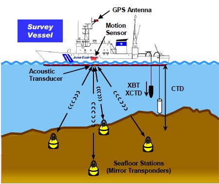
(This last sentence shouldn't make sense--GPS systems require an unobstructed "view" of a satellite to work, so a sensor on the sea floor shouldn't be able to communicate with a GPS satellite. However, by putting a lot of acoustic sensors on the sea floor, a ship or buoy can triangulate to figure out its exact relationship to the sensors, and then communicate with a GPS satellite to figure out its precise location. Here's a figure from the Japanese paper to illustrate:
So, here's the data they recorded, and if doesn't make your hair curl, something is dead in your soul:
So, bits of Japan lurched eastward 24 meters and rose by three meters. I'm trying to picture the place where I'm sitting doing that, and I confess that I am utterly failing in my efforts--let's see, I think it would place me on the roof of my neighbor's neighbor's house. This is plenty scary on its own--but here I am in Oregon, and the subduction zone off our coast is due for precisely this kind of megaquake. We're always cautioned the geographically separated earthquakes that occur close together in time are not connected. However, these megaquakes seem to be a different thing, and there's some opinion that they megaquakes around the Pacific rim may cluster--there was a bunch of them back in the early 1960's (Chile, Alaska, Kamchatka/Kuril islands) and now we may be seeing another bunch. I live well inland, but when I do go out to the Oregon coast, I take care to notice all the signs for tsunami evacuation routes. I appreciate geological drama, but its toll on human life overwhelms me. I prefer to view such drama with the remove of a scientific paper, or (as with the Sierras) at the distance of a hundred million years. It's scary enough for me.
Heki, Kosuke (2011). A Tale of Two Earthquakes. Science 322: 1390-1391.
C. Vigny, A. Socquet, S. Peyrat, J.-C. Ruegg, M. Métois, R. Madariaga, S. Morvan, M. Lancieri, R. Lacassin, J. Campos, D. Carrizo, M. Bejar-Pizarro, S. Barrientos, R. Armijo, C. Aranda, M.-C. Valderas-Bermejo, I. Ortega, F. Bondoux, S. Baize, H. Lyon-Caen, A. Pavez, J. P. Vilotte, M. Bevis, B. Brooks, R. Smalley, H. Parra, J.-C. Baez, M. Blanco, S. Cimbaro, E. Kendrick (2011). The 2010 Mw 8.8 Maule Megathrust Earthquake of Central Chile, Monitored by GPS. Science 322: 1417-1421.
Sato, Mariko, and Tadashi Ishikawa, Naoto Ujihara, Shigeru Yoshida, Masayuki Fujita, Masashi Mochizuki,Akira Asada (2011). Displacement Above the Hypocenter of the 2011 Tohoku-Oki Earthquake. Science 332: 1395.